Geotechnical investigation in Gisborne forms the critical first step in understanding the ground beneath any proposed development. This category encompasses a comprehensive range of subsurface exploration techniques, field testing, laboratory analysis, and engineering assessments designed to characterise soil, rock, and groundwater conditions. For a region like Tairāwhiti, where the terrain ranges from fertile alluvial plains to erosion-prone hill country, these investigations are not merely a regulatory formality but a fundamental necessity for safe and durable construction. Whether assessing a residential building site, a commercial subdivision, or critical infrastructure, the data gathered directly informs foundation design, earthworks specifications, and long-term risk management strategies.
The unique geological setting of Gisborne demands a particularly rigorous approach to site investigation. Much of the urban area and surrounding lowlands are underlain by relatively young, soft sedimentary rocks and alluvial deposits, interbedded with layers of volcanic ash and pumice from the Taupō Volcanic Zone. These materials can exhibit variable strength, high compressibility, and susceptibility to liquefaction during seismic shaking. The region's dynamic landscape, shaped by tectonic uplift and coastal processes, also means many sites are on or near ancient landslide complexes, particularly in the hill suburbs. A thorough investigation must therefore probe not just the near-surface soils but also deeper strata to identify potential failure surfaces and assess slope stability. Techniques like the CPT (Cone Penetration Test) are invaluable here, providing a continuous profile of soil behaviour and allowing engineers to pinpoint weak layers with precision.
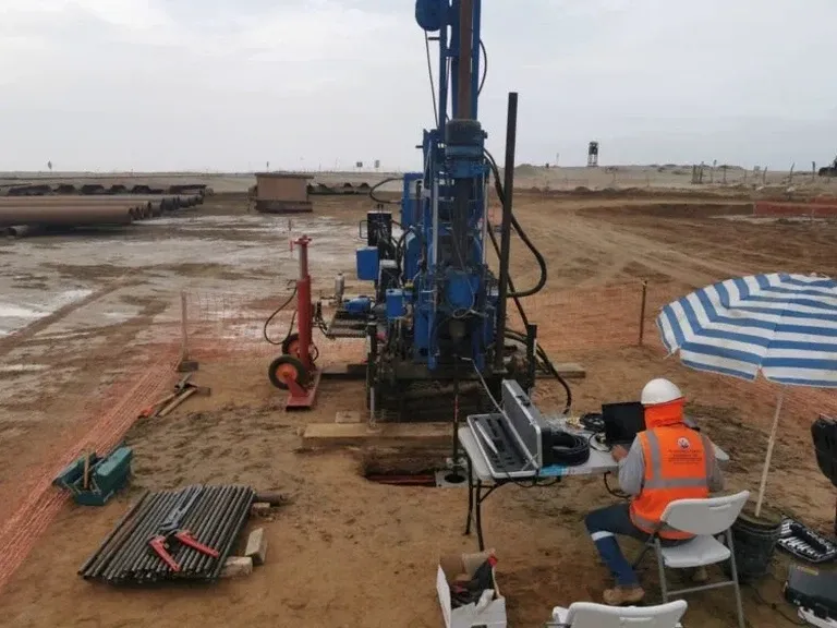
Navigating New Zealand's regulatory framework is a core function of any geotechnical investigation. All work must align with the Building Act 2004 and the New Zealand Building Code, specifically Clause B1 – Structure, which mandates that buildings withstand both ultimate and serviceability limit state loads. The joint Australian/New Zealand Standard AS/NZS 1170 for structural design actions, particularly Part 5 for earthquake actions, defines seismic hazard parameters that are especially stringent given Gisborne's location in a high-seismicity zone. The Ministry of Business, Innovation and Employment (MBIE) provides further guidance on ground investigation, with modules referencing the importance of site-specific data to modify the generic subsoil classifications in NZS 3604:2011 Timber-framed buildings. For liquefaction assessment, the MBIE/MfE guidance document is the prevailing authority, requiring a level of detail that often extends beyond a simple borehole to include in-situ testing methods like the CPT.
The types of projects requiring geotechnical investigation in Gisborne are diverse. Every new residential dwelling outside the scope of simple NZS 3604 'good ground' requires a site-specific assessment, particularly on the sloping sites that characterise much of the city's residential expansion. Commercial and industrial buildings, with their heavier loads and deeper excavations, demand a more detailed investigation program often involving multiple boreholes, trial pits, and a suite of laboratory tests on recovered samples. Infrastructure projects such as road realignments on State Highway 35, bridge replacements, and the district's crucial flood protection and stopbank networks rely on investigations to prevent failure and manage erosion. For these complex projects, integrating multiple methods is key. While a CPT (Cone Penetration Test) provides rapid, high-resolution data on soil stratigraphy and liquefaction potential, it is often complemented by boreholes with Standard Penetration Testing (SPT) to recover physical samples for visual classification and laboratory strength testing. This multi-faceted approach ensures a robust ground model, which is essential for the reliable analysis and design that underpin Gisborne's resilient future.
Available services
Quick answers
When is a geotechnical investigation legally required for a building project in Gisborne?
A geotechnical investigation is legally required when a building consent application cannot rely solely on the 'good ground' assumptions of NZS 3604. This applies to most sites with slopes, filled ground, or soils outside the standard's scope. The requirement is driven by the Building Code Clause B1, which mandates that foundations be designed for the specific site conditions to ensure structural stability and durability.
What is the difference between a desktop study and a full intrusive investigation?
A desktop study collates existing geological maps, aerial photos, and hazard data to identify potential risks before any ground disturbance. A full intrusive investigation physically tests the subsurface, using methods like boreholes, trial pits, or a CPT test, to verify the ground model and obtain quantitative data on soil strength, density, and groundwater, which is essential for engineering design.
How does Gisborne's seismicity influence the scope of a ground investigation?
Gisborne is in one of New Zealand's highest seismic hazard areas, making liquefaction and slope stability assessments critical. An investigation must evaluate the susceptibility of sandy soils to liquefaction under earthquake shaking, often requiring a CPT for precise, continuous profiling. The data is used to calculate ground settlements and lateral spreading risks that inform foundation and retaining wall designs.
What are the typical steps in a geotechnical investigation process?
The process typically begins with a preliminary site assessment and planning, followed by field exploration such as drilling boreholes, excavating trial pits, or conducting a CPT program. Recovered soil and rock samples are then tested in a laboratory. Finally, a geotechnical engineer analyses all data to produce a factual report and an interpretive design report with specific foundation and earthworks recommendations.